
News and Events
Archive
- March 2025
- February 2025
- January 2025
- December 2024
- November 2024
- September 2024
- August 2024
- July 2024
- June 2024
- May 2024
- April 2024
- March 2024
- February 2024
- January 2024
- December 2023
- November 2023
- October 2023
- September 2023
- August 2023
- July 2023
- June 2023
- May 2023
- April 2023
- March 2023
- February 2023
- January 2023
- December 2022
- October 2022
- August 2022
- July 2022
- June 2022
- May 2022
- April 2022
- March 2022
- February 2022
- January 2022
- December 2021
- November 2021
- October 2021
- September 2021
- August 2021
- July 2021
- June 2021
- May 2021
- April 2021
- March 2021
- February 2021
- January 2021
- December 2020
- November 2020
- October 2020
- September 2020
- August 2020
- July 2020
- June 2020
- May 2020
- April 2020
- March 2020
- February 2020
- January 2020
- December 2019
- November 2019
- October 2018

Surveyor’s Week - A Global Event
Surveyor’s Week is a great time to recognize the work of surveyors and their contributions, not only within the United States, but around the world. In our many blogs about surveying and famous surveyors, we’ve mainly focused on this country, but surveying is just as important around the world as it is here.

Alice Fletcher - the first American female surveyor
Surveying is one of the few professions where practitioners truly leave their mark, both physically, with survey markers, as well as in recorded history. Sometimes this work is truly monumental, as is the case with Alice Cunningham Fletcher.
Fletcher was born into wealth – her father was a prominent New York attorney, and her mother came from a wealthy Bostonian family. Unfortunately, her father’s health was poor and the family moved to Havana, Cuba shortly before Fletcher was born in the hopes the climate there would improve his health. However, the climate change didn’t work, and her father passed away in 1939 when Fletcher was only a year old.

A surveyor who made his mark on the nation
Surveyors have special reason to celebrate President’s Day, since Washington, Jefferson, Lincoln and even Teddy Roosevelt all had surveying and map-making in their backgrounds. Jefferson’s surveying experience informed his acts as president, including the establishment of the Public Land Survey System (PLSS) and the Louisiana Purchase that added 827,000 square miles of land to the United States.
By the 1800s, the westward expansion was continuing unabated, despite land being inhabited by indigenous peoples as well as claimed by other countries.

Mount Everest - named for a paragon of surveying
Did you know that the highest mountain in the world is named for a surveyor who never laid eyes on it?
George Everest was the Surveyor General of India from 1830-1843, during the time when Great Britain was consolidating its control over the country in order to have full access to its vast resources. His work was so important to the fulfillment of that goal that the mountain was eventually named after him – despite his protests.

Hoover Dam - a wonder of surveying
The dizzying pace of technological change is overwhelming at times. But no matter what changes, surveyors keep us grounded, because they know precisely where we stand, X, Y and Z. Surveyors have been setting the markers for progress since ancient times – the early Egyptian and Roman architectural wonders were based on the work of early surveyors. Colonial surveyors were key to the founding of the United States, not only by parsing out boundary lines for European settlers, but by nation-building – helping to author the Declaration of Independence, then helping to create a new kind of government for the new nation.

Exciting trends point to a great 2023
Money, Money, Money
Infrastructure is no longer an ignored necessity in the United States. Thanks to the Bipartisan Infrastructure Law signed in 2021, our country is making a once-in-a-lifetime investment in its economic backbone to the tune of $1.2 trillion over five years. In 2022, 6,900 specific projects have been launched in 4,000 communities in all 50 states.

Thank you for 50 years!
What a half-century it has been! Back in 1972, when Berntsen was founded, the world was a different place. There was no internet (it wouldn’t be available until 1983) ; social media wouldn’t show up for another 25 years. People had to communicate by landline telephone, snail mail, telex – or even talk face-to-face!
Technology was beginning to change surveying as well – Berntsen introduced the first lightweight aluminum alloy monument, making surveying less arduous; at the same time, Electronic Distance Measurement (EDMs), were being used in conjunction with theodolites, speeding up surveying. By the 1980s, surveying was becoming increasingly digitized, and by 1990, the digital total station was introduced.

Berntsen & Schonstedt - the partnership is magnetic!
Berntsen and Schonstedt are two companies that were founded on sound science and good ideas – and a strong commitment to make the world a better place.

National 811 Day - little known but important!
It’s National 811 Day – a very important, but little-known commemoration. Anyone who is planning to disturb the ground should call this number before digging or excavating – or go to call811.com and connect online. Once you provide the area of excavation, locators will come out and mark the location of buried gas pipes, water lines, power cables and other underground utilities.
Ferdinand Vandeveer Hayden and our first national park
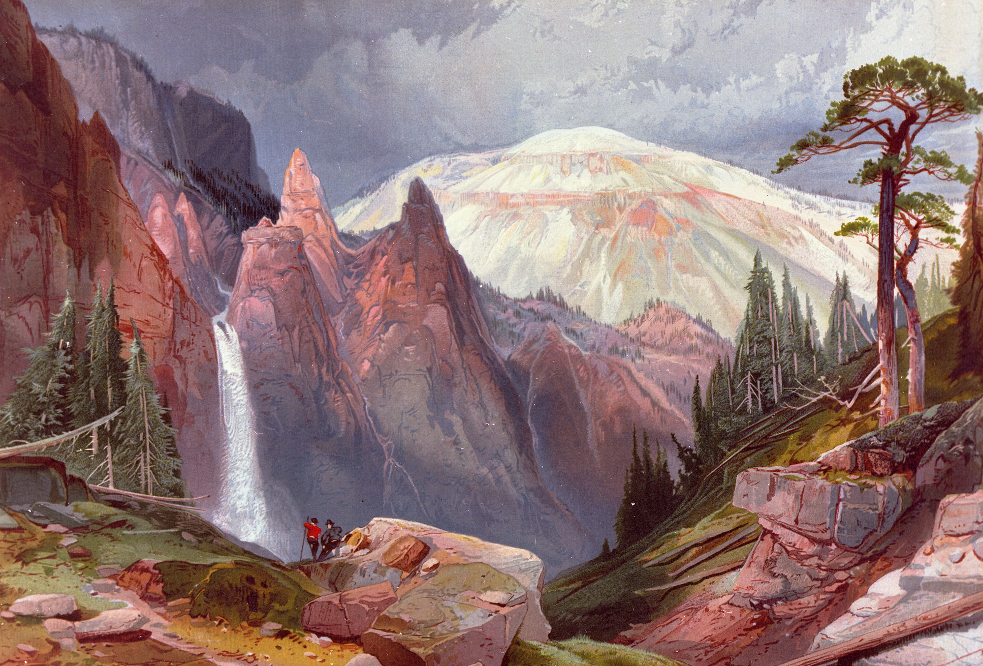
Surveyors are natural explorers, so they appreciate and enjoy the beauty and infinite variety of nature every day. Unless you choose a profession that includes the outdoors, people must intentionally plan a trip to a county, state or national park. Most people aren’t aware that surveyors were instrumental in the creation of our National Parks, including our first – Yellowstone National Park.
Robert Erskine - Inventor, engineer, surveyor and patriot
It’s hard to overstate how important surveying was to the establishment of the United States – three of our presidents were surveyors, as well as six of the signers of the Declaration of Independence. But even before there were presidents, surveying and cartography played an essential role in the fight for independence.

Steve Parrish ‒ A Living Legend
I’m sure most surveyors have heard of the “Final Point” program created by Berntsen International, Inc. and the National Society of Professional Surveyors Foundation (NSPSF). It’s a way to memorialize the work of beloved surveyors who have had a lasting impact on the profession, while supporting the future of surveying through NSPS/Berntsen scholarships.

The InfraMarker® RFID App Now Livein the Esri ArcGIS Marketplace
Madison, Wisconsin – March 7, 2022: Berntsen International, Inc., was recognized with the High Potential Award at the 2022 Esri Partner Conference (EPC) held in Palm Springs, California March 5–7, 2022. This award was presented to Berntsen International Inc., for the substantial opportunity for growth represented by its InfraMarker® Connected RFID™ solution that links the power of ArcGIS with RFID asset marking to deliver more accurate and efficient field operations.
Operation Overlord
Seventy-eight years ago today, Operation Overlord was launched – known as D-day, one of the greatest combined military operations ever undertaken. It was ambitious on a size and scale that is unparalleled to this day. What isn’t often remembered is what it took to plan the invasion. Everything about the landing sites had to be known – a tall order because the entire coast was enemy territory. That’s where surveyors and reconnaissance experts came in.

A life of precision - Andrew Ellicott, officer, surveyor, diplomat and teacher
Andrew Ellicott’s family emigrated from Wales to what is now Bucks County in Pennsylvania in 1731. They had to leave Wales because Ann Bye Ellicott was a Quaker and when she married Ellicott (a non-Quaker), they were disowned and needed to start anew.
Andrew Ellicott was the first of nine children born to Joseph and Judith. The family continued the Quaker faith, finding welcome in a state founded by a Quaker, William Penn. Joseph supported the growing family by working as a miller and clockmaker. The children were educated at the local Quaker school, where Andrew’s talent for math and mechanics was encouraged and developed.

Marking and Mapping - Two-factor Verification for Underground Locating
It’s spring and construction is booming . . . hopefully with fewer actual “booms”, caused by utility strikes. Safe digging is something that’s near and dear to surveyors and any profession that involves excavation. As I mentioned in my last blog, preventable utility strikes cost at least $60 billion annually, not to mention the loss of life and life-altering injuries that can occur.

April is Safe Digging Month - for good reason.
As surveyors intimately understand, it’s very important to know what’s below. Your life could depend on it. National Safe Digging Month was created in 2008 by the Common Ground Alliance (CGA) to bring visibility to protecting workers, utilities and the public by working to prevent utility strikes during excavation. This group is comprised of companies and individuals in every facet of the underground utility industry, including Berntsen.

Yellowstone's Moving Monuments
Yellowstone was established by Congress as the world’s first national park on March 1, 1872, following three expeditions to the region (the Folsom-Cook-Peterson Expedition of 1869; the Washburn-Langford-Doane Expedition of 1870; and the official, government sponsored Hayden Expedition of 1871). The expeditions were seeking the truth to the numerous rumors about the area that was described as “smoking with the vapor from boiling springs; and burning with gasses . . . “ (Joe Meek, fur trapper, 1829). What the men of these expeditions saw astounded and inspired them. The unique geology of the area galvanized them to petition Congress to set the area aside as a “public pleasureing-ground” protecting from “injury or spoliation” the “timber, mineral deposits, natural curiosities or wonders within said park, and their retention in their natural condition.”

Underwater by Design
Near midnight on August 4th, 1984, the M/V Wellwood, a 400-foot steel-hulled freighter, struck Molasses Reef in the Florida Keys National Marine Sanctuary. This wasn’t good for the Wellwood, and it was disastrous for Molasses Reef; 1,280 square meters of coral reef habitat was Molasses Reef / Wellwood Restoration Site Monument utterly destroyed, reduced to pulverized coral rubble.
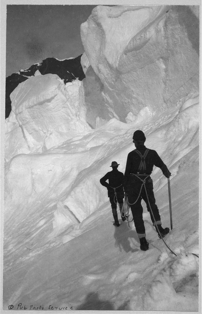
Denali . . . Maybe not just a hike up the mountain
In June of 1989, a team of eight men ─ formally called The 1989 Mt. McKinley Global Positioning Expedition ─ set out from a base camp to perform one of the most unusual survey projects the world has ever seen. Their mission was to verify, by the most sophisticated satellite positioning methods, the true summit elevation and position of the highest mountain peak on the North American continent, Denali. [Mt. McKinley was renamed with its original name, Denali, in 2015]. The project involved hundreds of hours of planning, thousands of dollars in costs, the use of the most up to date global positioning equipment to track several special military communication satellites orbiting the earth . . . and one Berntsen Survey Monument, which was placed precisely at the summit.