A quick sprint through the history of marathon . . .
Marathon County, Wisconsin, that is!
Blog by Emily Pierce, PLS, CFedS

Map of “New France” by Samuel de Champlain, ca. 1850. Jean Nicolet would have come to Wisconsin in 1836 on the southern shore of Mer douce (Green Bay) as depicted in this highly inaccurate map.
I was recently invited to speak at the Wisconsin Society of Land Surveyors (WSLS) annual summer meeting. I decided to delve into the history of my own county here in Wisconsin - Marathon County - where I spent 13 years of my surveying career. I thought I knew a bit about its history, but I had no idea how interesting it was. I’ve already blogged about the importance of surveying in colonial times, and my “Marathon” research underscores the importance of surveying in laying out the foundation for organized economic development in Wisconsin.
Early History

Bedrock geology of Marathon County
Here in Marathon County, Wisconsin, we often think of our history as beginning with the appearance of Jean Nicolet in the Red Banks of Green Bay in 1634, then later with the arrival of George Stevens in the 1830s.
But as surveyors know, there’s different kinds of history, and I’ll start with a little geologic history. It turns out that the rocks in central Wisconsin are some of the oldest in the state – nearly 3 billion years old. Marathon County has hosted a mountain range, been submerged, been covered with lava, and compressed by glaciers. These forces have rendered some of the most beautiful landscapes in the state, and made it a place for all kinds of plants and animals – including people.
It’s thought that the first people migrated into the area about 10,000 years ago. By the time the first French fur traders appeared in 1654 (which is when we start having some historical documentation) Marathon County was home to the Ojibwe, Sac, Fox, Winnebago, Chippewa, Menominee, Ho-Chunk and other tribes, who hunted in the rich forests and farmed corn, potatoes oats, rye and barley.
Early on, the residents were probably unaware that their land was part of the Northwest territory (1788-1800). By 1812, the British had lost the War (of 1812) and more and more traders and settlers moved in. By 1820, Wisconsin’s population of settlers and traders was estimated to be 1,444 and growing rapidly. Everything was in flux – including its designation. Wisconsin was subsequently part of the Indiana Territory (1800-1809), the Illinois Territory (1809-1818) and the Michigan Territory (1818-1836). By 1836, the population of settlers had surpassed 10,000.
Back in 1830, Marathon County was at the cusp of major economic changes, with businesses ready to move in and generate wealth from its vast natural resources. The area from the Dell Prairie River to Lake Superior had come to be known as the “The Pinery”. Marathon County was a lumber baron’s dream, situated right in the middle of The Pinery, fed by the Big Bull River (now known as the Wisconsin River), the Big Eau Pleine River, Big Rib River and others.
A Place for Dreamers who could work hard
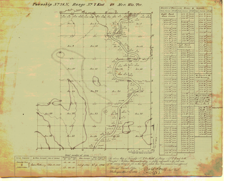
Original survey of the 48-mile strip along the Wisconsin River by Joshua Hathaway.
One of the dreamers, George Stevens, a lumberman originally from New York, heard about the treasures of Wisconsin while working in St. Louis in 1838. He decided to check out the rumors and took a trip to find out – and ended up building a mill at Big Bull Falls, on land he and some partners purchased from the US government on land formerly owned by the Winnebago tribe.
Of course, Stevens and his partners weren’t the only people rushing in and trying to get rich from the abundant natural resources – so naturally, disagreements about ownership of forest lands were a source of conflict. The 1836 Treaty of Cedars (where the Menominee people sold their land to the US Government) included a clause that an official survey of the 48-mile strip along the Wisconsin River was to be made. As I’ve mentioned in earlier blogs, surveying was key to the growth of the modern United States. The fact that many of our early presidents (Washington, Jefferson and Lincoln) were surveyors underscores the importance of surveying to economic growth.

DOT map of Wisconsin
In the spring of 1839, a surveyor named Joshua Hathaway from Milwaukee began the survey. He started about five miles south of Daniel Whitney’s Mill at Point Bausee and completed the survey at Big Bull Falls, just before winter set in. (More about Hathaway coming in a future blog).
By 1840, the Stevens sawmill was processing the pine forests into lumber. Before long, other mills began springing up along the riverbanks of central Wisconsin, and surveyors were busy creating plats, laying out roads and towns.
By 1844, the site had two additional lumber mills, a boarding house, a few shanties that were used as factories to produce shingles and two houses owned by Stevens. More and more enterprising settlers arrived, and by 1850, the settlement had come to be called Wausau, a name derived from a Menominee name of the area that meant “Far Away Place”. By 1852, Wausau had been platted and organized as a town and by 1872, it officially became a city – and eventually the county seat of Marathon County.

Fortunately for Wausau, it did not suffer the fate of many boom towns that spring up around natural resource extraction – it managed to transition from lumber mills to paper-making, then to insurance. Part of this good fortune was its location at one of the best sources of water power in Wisconsin, and the other part were a group of leaders who supported long term economic efforts.
Today, paper and other manufacturing drive the economy, along with health care, education and tourism. I might be biased, but Wausau is a great place to live, work, and play, and I’m glad I took the time dig into its history and the background of Marathon County.
Resources:
https://www.ci.wausau.wi.us/Home/AboutWausau/HistoryofWausau.aspx
https://www.wisconsinhistory.org/Records/Article/CS3586
https://en.wikipedia.org/wiki/History_of_Wisconsin#French_period