
News and Events
Archive
- April 2024
- March 2024
- February 2024
- January 2024
- December 2023
- November 2023
- October 2023
- September 2023
- August 2023
- July 2023
- June 2023
- May 2023
- April 2023
- March 2023
- February 2023
- January 2023
- December 2022
- October 2022
- August 2022
- July 2022
- June 2022
- May 2022
- April 2022
- March 2022
- February 2022
- January 2022
- December 2021
- November 2021
- October 2021
- September 2021
- August 2021
- July 2021
- June 2021
- May 2021
- April 2021
- March 2021
- February 2021
- January 2021
- December 2020
- November 2020
- October 2020
- September 2020
- August 2020
- July 2020
- June 2020
- May 2020
- April 2020
- March 2020
- February 2020
- January 2020
- December 2019
- November 2019
- October 2018
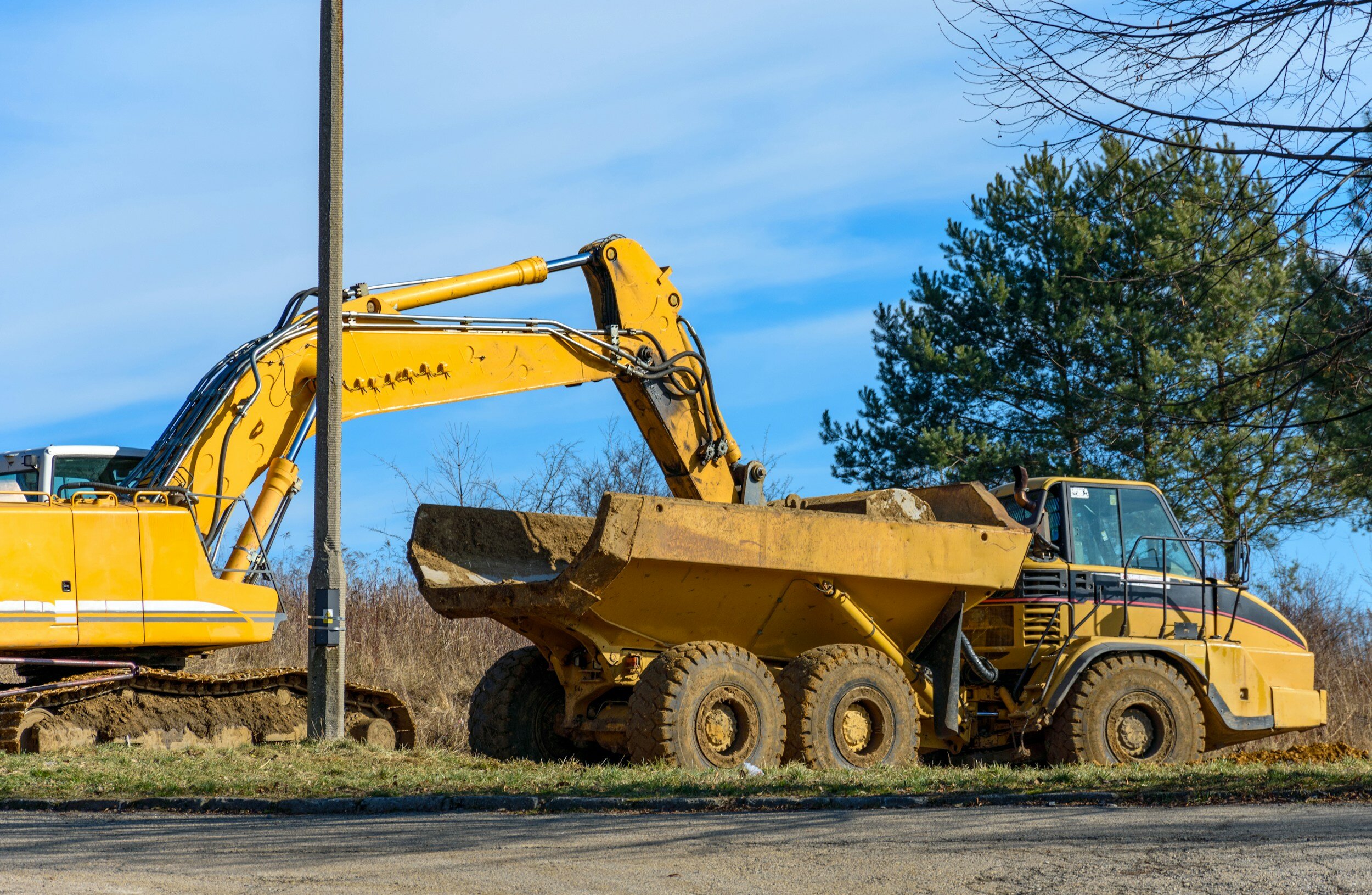
Damage prevention saves lives and money
April is recognized by Congress and most Governors across the U.S. as National Safe Digging Month as shovels (and backhoes) hit the ground for a busy season. It’s well known that excavation is a dangerous business. Excavation strikes on public utility lines lead to more than 2,000 injuries and 400 deaths each year[1]. The Common Ground Alliance (CGA) states that accidental utility strikes cost the U.S. at least $30 billion annually, based on self-reported data by stakeholders and state 811 call centers. And it looks like things are getting worse, not better.

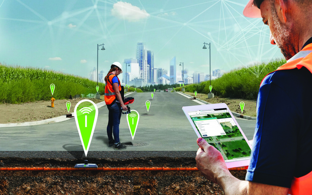
RFID + GIS = SUE Enhancement
Subsurface Utility Engineering (SUE) that leverages Geographic Information Systems (GIS) and Radio Frequency Identification (RFID) deliver substantial benefits in the management and protection of underground assets.

RFID - technology that keeps on giving
We’ve all heard of RFID, a technology that’s been around since the 1930s. Did you know that it’s now one of the fastest-growing technologies in the world?
Marking and Mapping - Two-factor Verification for Underground Locating
It’s spring and construction is booming . . . hopefully with fewer actual “booms”, caused by utility strikes. Safe digging is something that’s near and dear to surveyors and any profession that involves excavation. As I mentioned in my last blog, preventable utility strikes cost at least $60 billion annually, not to mention the loss of life and life-altering injuries that can occur.

Today is GIS Day!
Most people don’t really think about how geographic information provides the framework for our entire existence. We exist as living organisms in time and space. Our minds may be occupied with far-way thoughts, but our memories are inextricably tied to the place where they were created. As long as we live and breathe, we always have a location. Shakespeare’s Hamlet said “To be or not to be, that is the question.” Surveyors say, “To be is to occupy a position relative to two axes.”

A Dam-aging Stormwater Report Card from ASCE
Urban flooding results in more than $9 billion in damages annually, while federal funding to support stormwater maintenance/upgrades averages about $250 million annually. It’s not surprising that stormwater infrastructure is in bad shape and has earned a grade of “D” from the ASCE.

It's World Creativity and Innovation Day
The United Nations passed a resolution creating this day to celebrate the creative economy, which actually makes a lot of sense, considering the entire world is just beginning to come out of a pandemic that really forced us all to get creative just to do our jobs.
Fortunately, surveyors have made creativity a way of life. It seems like we have a pretty straightforward job – use our tools to verify property lines, monitor structures for movement over time, lay out the lines for construction, etc.

GIS Day is November 18
Little did I know that dusty old geography would become the one of the most interesting (and explosively-growing) fields in science. Today Geographic Information Systems (GIS) is shaking up the world of geography – and statistics, data analysis, spatial data, modeling, geostatistics, cartography, data integration, GPS – and on and on.

811 - Essential to Call Before You Dig
Earlier this week we commemorated National 811 Day. On August 11 we were reminded to call 811 (or visit call811.com) before digging – in our yards or at a construction site. This simple reminder has saved lives and repair costs by preventing accidental damage to power lines, gas lines and other buried utilities during excavation.

Mapping the Grand Canyon - the challenge that took a century
The history of Grand Canyon mapping and surveying is almost as convoluted as the canyon itself. The task requires vision, a special set of skills, determination, money, endurance and luck - nevertheless, many explorers and surveyors have accepted the challenge and produced some of the most beautiful maps ever created.

How Underground RFID Marking is Changing the Utilities Industry
You would think that with all of the technology available today, we’d be able to see what’s underground almost as well as we see what’s above ground. Unfortunately, that’s not the case - underground utility locating remains an issue.

The Crucial First Step in Fixing America's Aging Underground Utility Infrastructure
Over the next 20 years, upgrades to the nation’s water system alone are expected to cost three to five trillion dollars. Yet appropriations to replace critical infrastructure continually fall short. Municipalities and utility companies are under enormous pressure to make existing assets more efficient.

Surveying the future with RFID
Next, we deploy our drone outfitted with GNSS, a magnetic locator and RFID transceiver to hover over each monument coordinates to confirm the existing monuments and search for any missing monuments.

Disasters Underscore Critical Need for Connected Utility Infrastructure
On Sept. 14, 2018, Hurricane Florence slammed into the Carolinas, bringing with her powerful winds, torrential rains and the potential to wreak catastrophic destruction. Though Florence was downgraded to a Category 1 storm as it moved over land, its high winds and rain toppled trees, triggered massive flooding and caused power transformers to explode like fireworks, leaving hundreds of thousands of people without power. More than 40 people have died as a result of the storm and flooding.